
Dynamics/Activities (Five activities are listed for now; others will be subsequently added)
1. Mapping of ILDC partners in one geospatial platform for building cumulative visibility, synergistic information sharing, and greater impact
The platform will include all ILDC partner information and their area of work including geographic locations, a major area of intervention, types of intervention and association. This information will be plotted over an India map with relevant search/ filter options to drill down to specific geographies or institutions and it's/ their work. This will have an option for many to many mapping where a single institution can be mapped over various geographies and one geographic location can be mapped for different institutions. The geographic location filter will initially have scope till block level.
The institutional mapping will be based on their core area of work/ theme such as women land rights, tribal land rights, land acquisition, land conflict, technology for land mapping, farmer’s rights etc. Institutional mapping will also include events such as workshops, advocacy camps, rallies, campaigns, movements, etc. planned by the institutions. The event details will include event name, dates, venue, expected participants, the category of an event such as workshop, training, rally, advocacy, book release, etc., and official link to access the event details/ registration for the event. These events and activities can be connected and/or converged at national (viz. ILDC) and global level with a scope of also two-way process, with national events, also leading to regional and locals, thereby making more logical flow and systemic connections.
The platform will be updated periodically by seeking information from the partner institutions and also providing self-updating link to the partners. The platform will be hosted in a separate website (can be landtenurehub.org or landgov.org which are already registered by us) with a link to each partner website.
We are planning to began working on this, by collecting some information from ILDC partners this year and trying to show a bigger picture of our presence and work in an Interactive India Map .
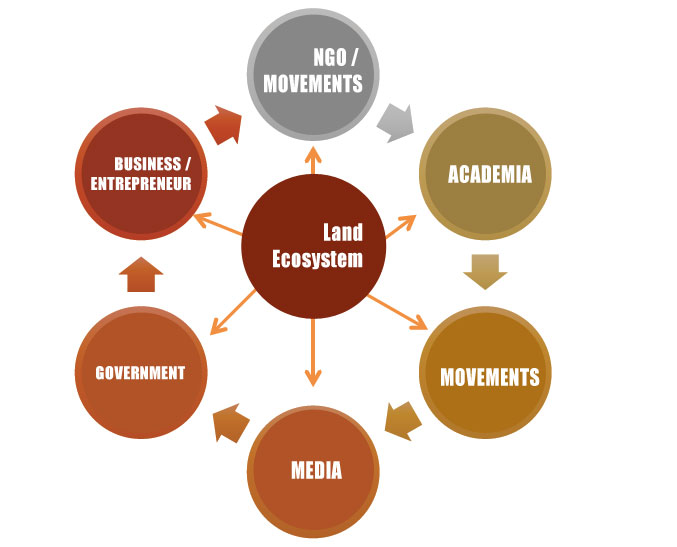
2. Academic Alliance around Land-Researchers for better connecting them and with Policy and Practice actors
Using ILDC platform, the idea is to bring together scholars and institutions working on and around and at the interface of the field of land tenure governance from diverse backgrounds. This alliance seeks to improve connection among academia with practitioners and policy-influencers working in Governments, NGOs, movements and businesses catalyzed by ILDC platform. It will trigger more
research, action and consulting engagements benefitted through such partnerships. Increased engagements of academia in land related research, capacity building and academic (e.g. courses, diplomas, degrees etc.) activities will result through such cooperation and collectivized actions. It is expected that increased information, data and evidence generation and availability in open access, digital and geo-spatial domains, would contribute to better monitoring (including SDG) and more informed actions and decisions. FES has a rich experience in mobilizing and connecting researchers not only from India, but also from premiere global institutions, with its work on ground. We are working on such an idea with the network of ILDC to begin with and propose to have the first meeting with available academicians during ILDC2019.
3. Building interest and capacity among media professionals and establish interface with policy and practice actors for higher media coverage of land rights stories.
Through journalist workshops, fellowships and other kinds of engagements, more interest, reporting and publication of land rights stories are expected in media. ILDC has already begun the process with a Data Journalisim Workshop partnering with IndiaSpend during the last event and also organizing another such workshop with Thomson Reuter Foundation.
4. Establishing a Land Information Ecosystem by working with actors: users and providers, working around land-data cycle and also connecting data sources
While, there are many sources of information about land, but their visibility, accessibility, consistency and completeness vary enormously. Finding solid evidence upon which to base policy and practice involves a lot of work. Policy progress on land governance is threatened by lack of good information. Now, more than ever, it is paramount that awareness is raised amongst key land actors including policy makers on the importance of information sharing, knowledge management and, more
specifically the power of an information ecosystem.
There is a need to assess the land information availability and accessability in India and how are they organized in terms of data standards, openness, inter-operability and protection. It is also important to explore if and how an information ecosystem can be built to synergize and enhance information sharing and impact. CLG-NRMC had started developing a State of Land Information Report as a pioneering country-initiative with Land portal in 2017, and followed up with releasing a State of Land Report during ILDC2018. International Land Coalition country partners will also be working towards developing a people’s dashboard on SDG indicators shortly, following a similar pilot in Nepal. Partners of RRI and WRI are also working on databases, so as many grassroot NGOs and movements (viz. Ekta Parishad). Government with focus on digitization and open data, is also developing and dissemination wide range of land data including initiatives like DILRMP, NSSO, Agriculture Census etc. FES has been working on a India Data Observatory with a big land focus. ISB’s India Data portal also considers land data. As a side event of ILDC2019, a workshop on Open Data Ecosystem is also organized this year to discuss with diverse land data users and providers if and how such an ecosystem can be established.
5. Developing a partnership ecosystem around digital mapping solutions
Secured land rights are key to conservation, productivity increase and sustainable development. Documented, updated and transparent land records syncing textual and spatial land records with on ground tenure reflecting prevailing law/custom, is key to secured land rights and critical for sustainable development (SDG indicators 1.4.2 and 5a1). However, in India, about 1.5 billion parcels either remain un-updated or un-surveyed, with a minimum of 10% needing updating every year, due to transactional and inheritance changes. While most of existing 264 million land records remain old and un-updated as per DILRMP, recognition of
forest rights as per FRA, 2005, surveying of un-surveyed land under customary tenure regimes in NE India as well as constituting post-survey land grants (viz. homestead, usufruct rights, ceiling surplus and agricultural land etc.) etc. add up to the task.
The need of such massive mapping and regular updating task is very difficult to achieve through a conventional survey with the existing capacity of land departments in terms of ground force, skills and resources, which remain awfully lacking. Technology can come to rescue with fast emerging of diverse options promising to make mapping more inclusive, less costly, more efficient and easy to handle. IT use is growing in emerging economies and cheaper smartphones/tablets have become now more ubiquitous. Mapping options are more evolved, universal, less costly and more accurate with expanding GIS infrastructure and technologies as well as increasing availability and high resolution of satellite imageries and increased access to (and lower cost) of drones.
There is a strong need in India, of building a community-sourced and led inclusive mapping ecosystem. This can be a flexible digital platform (web and mobile interfaces) integrated with appropriate social-institutional-legal systems to effectively and efficiently map diverse land tenure situations. Community-led land tenure mapping as an inclusive digitalized platform is the compelling need for ensuring land tenure security in the form of new and updated land records created through transparent, democratic and inclusive processes, while ensuring desired as well as fit-for-purpose accuracy.
A partnership ecosystem approach is however required to address the enormous gap, mobilize diverse skills and resources required and also to augment efficiency, ensure inclusion and embed sustainability. Engagement of media (electronic, print and social) and information networks would build impetus around informed-demand by all critical stakeholders. Academia, particularly survey schools and training institutions will help in churning out trained youth required to facilitate the process in village clusters.
Participation of local governance institutions (viz. Forest Rights Committee, Gram Sabhas, Village authorities etc.) in formal and customary systems is critical to address democratization and decentralization as well as to understand rights-continuum to ensure transparency and acceptability.
Involvement of Government departments (viz. land, forest, tribal, urban, industry etc.) is imperative to ensure buy-in and ownership and to help building a dynamic and adaptive interface with existing institutional framework around surveying and mapping to ensure stipulated legitimacy and sustainability.
Donors and Private sectors would bring in desired investments for technology development, alignment and adaptive upgradation partnering the social-entrepreneur developers/disrupters, data aggregators and intermediaries. Land being a critical stratum for any investment, the participation of bankers and insurance companies dealing with land mortgage and investments are also called for.

The partnership ecosystem around mapping platform and their actors, esp service and technology providers are going to be critical catalysts of India Land Ecosystems. Technology institutions and start-ups as well as financial institutions look at land rights differently and have not been able to realize their potentials in improving it. This business unusual has immense potential to make land tenure security more inclusive at low cost, in a short time with due community participation and control. Mapping ecosystem development is also critical for achieving SDG. As part of the whole land ecosystem, it has also potential symbiotic linkages with academia, media, and other sub-systems.
Prepared by: Pranab R Choudhury
NRMC Centre for Land Governance